Integrated routing and warnings in Track of the day
After calculating a route, Track of the day may show the notice “No offline data for this area – HERE routing used” and the “Warnings and Errors” window. This is not an error. This page explains what the message means, how to use the warnings window, and how to make sure the message no longer appears.
The video shows every step on this page. The guide below is complete without the video as well.
What the message means
By default, Track of the day calculates routes with the integrated routing. It runs directly on your computer, needs no internet connection and is free of charge. For that it needs the offline data of the region your route is in. If this data is missing, Track of the day automatically calculates the route with the online service HERE – with the same vehicle settings – and tells you so.
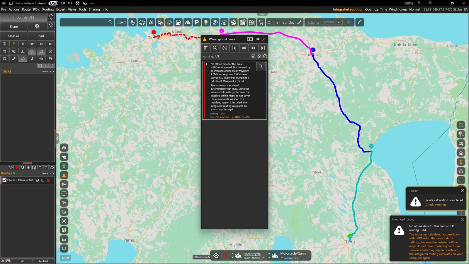
- “Caution – Route calculation completed – Check warnings”: there is at least one note about this route.
- “Integrated routing – No offline data for this area – HERE routing used”: the reason. Close the notices with the cross, or they disappear on their own after a few seconds.
- The “Warnings and Errors” window shows the same message and lists the waypoints that are not covered by an installed offline map.
Your route is fine. As soon as a matching region is installed, the integrated routing calculates on your computer again and the message no longer appears.
The automatic fallback via HERE also applies in the Free Edition. Without an internet connection and without offline data, Track of the day draws a straight line instead and points this out as well.
The “Warnings and Errors” window
The window lists all notes about the route that was just calculated. The numbers in the picture refer to this list:
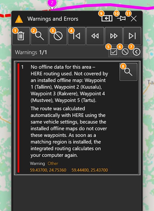
- Bin: delete all warnings; the pins on the map disappear as well.
- Magnifier: show all warnings as pins on the map and zoom to them.
- Prohibition sign: hide the pins on the map. The warnings stay in the list.
- Arrows: jump to the first, previous, next and last warning.
- Tick: select all warning types (“Warnings 1/1” shows the count).
- Small prohibition sign: deselect all warning types.
- Arrow: expand or collapse the list of warning types with check boxes.
- Magnifier on the entry: show exactly this warning on the map. The orange coordinates below it open Street View.
- Dock: attach the window to the right of the main window at full height (click again to release it).
- Pin: pin or unpin the window. A pinned window always stays open.
- Cross: close the window.
Closing the window for good
If the window is pinned, it stays open even for routes without warnings, and Track of the day remembers this after a restart. To close it:
- Click the pin (10) in the title bar. The window is now unpinned.
- Click the cross (11).
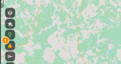
- From now on the window only opens when a route really has warnings. You can bring it back at any time with the warning triangle in the toolbar to the left of the map.
Install an offline region – so the message disappears
Download the offline data of the regions in which you plan routes. A region’s map and routing data are downloaded together.
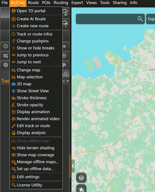
- Open the “Actions” menu and choose “Manage offline maps...”.
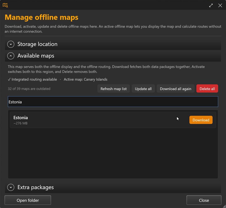
- The “Available maps” section lists all regions with their size. Type the name of the region into the search box, for example “Estonia”, and click “Download”.
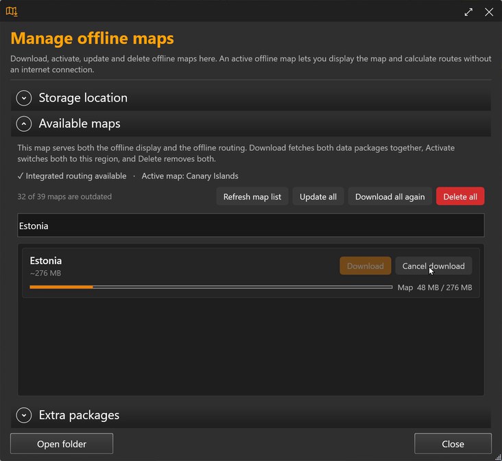
- The bar shows the progress, first for the map, then for the routing data. “Cancel download” stops it; what has been downloaded is kept, and you can resume later.
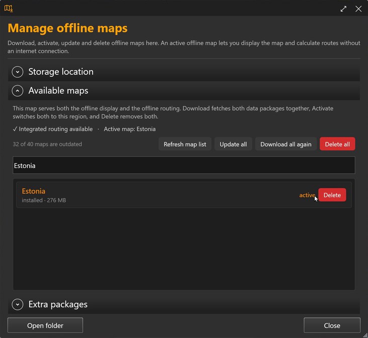
- The region is then “installed” and “active”, and the top line reads “Active map: Estonia”. Close the window with “Close”.
- Calculate the route again (“Calculate route” button in the profile bar at the bottom). Now the integrated routing calculates it – without a notice and without a warning.
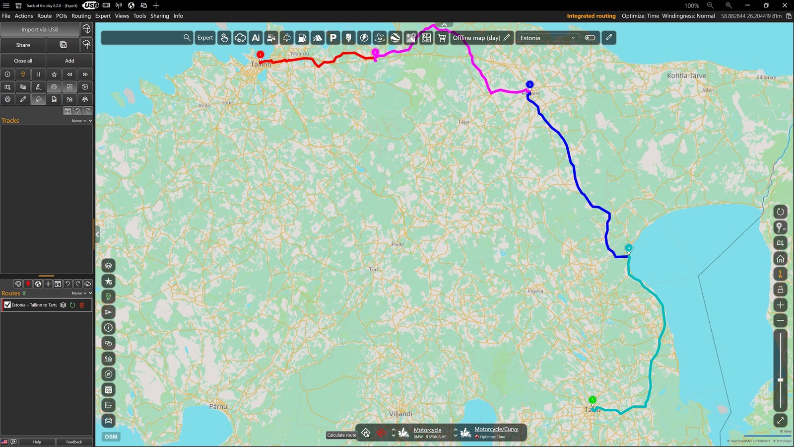
The same route, now calculated with the integrated routing and the Motorcycle/Curvy profile.
Tip: The map bar at the top offers the region at the centre of the map for download directly, including its size. Click the blue arrow to start the download.

Small regions download in a few minutes; large countries such as Germany or France take up several gigabytes. You can see and change the storage folder in the “Storage location” section of the same window.
A region is always used as a whole. If a route crosses a border, choose a region that covers both sides, for example “Alpine region”.
Where routing is set
The method belongs to the routing profile. Clicking the profile name in the profile bar at the bottom opens the “Routing Profile” window; the “Routing type” field says “Integrated routing (no internet connection required, free of charge)”. The active method is also shown in orange at the top right.
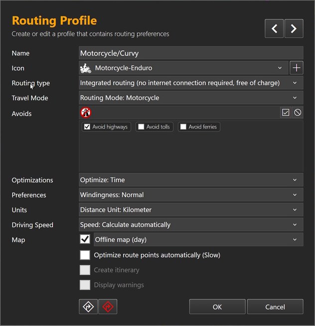
- Free Edition: integrated routing and straight line. If offline data is missing, HERE helps out automatically.
- Pro licence: you can also set HERE, Azure Maps, Google Maps or GraphHopper as the routing type. That service then always calculates, and the “Integrated routing” notice does not appear.
- Without internet and without matching offline data you get a straight line. You can recalculate the route later at any time; nothing is lost.
What changed with version 8.1.4 and 8.2
- Since version 8.1.4, all built-in routing profiles use the integrated routing. The profiles no longer carry numbers (formerly “0 - Offline”, “1 - Fast” and so on).
- When 8.1.4 started for the first time, profiles and garage were converted once. The previous files are in “Documents\Track of the day\RoutingProfiles\_Sicherung-vor-v8” and “…\Garage\_Sicherung-vor-v8”. With a Pro licence your own profiles are kept after the new ones.
- Since then, if offline data is missing, Track of the day calculates with HERE automatically instead of asking – also in the Free Edition.
- New in 8.2: one Pro licence covers the whole TD suite, and you pair your devices with a short code in the TD portal. The new sign-in
Frequently asked questions
Is my route wrong?
No. It was calculated with HERE, using the same vehicle and mode settings. The only difference: HERE calculates a motorcycle like a car.
Does the HERE calculation cost anything?
No, the automatic fallback is included in the Free Edition too.
Can I switch the message off?
There is no setting for that. The message disappears as soon as the matching region is installed. With a Pro licence you can alternatively use a profile with an online service as the routing type.
The warnings window opens every time I start the program.
Then it is pinned. Unpin it and close the window (see “Closing the window for good”).
I installed a region and the message still appears.
The message lists the waypoints that are not covered. Check that all waypoints lie inside the installed region; for routes across borders a larger region helps. Then calculate the route again.